State Board of Education
| Term Expires | |
| Edwin L. Novak, O.D., President Flint | Jan. 1, 1973 |
| Michael J. Deeb, Vice President Detroit | Jan. 1, 1977 |
| Dr. Gorton Riethmiller, Secretary Chelsea | Jan. 1, 1975 |
| Thomas J. Brennan, Treasurer Dearborn | Jan. 1, 1979 |
| Marilyn Jean Kelly Detroit | Jan. 1, 1977 |
| Annetta Miller Huntington Woods | Jan. 1, 1979 |
| Dr. Charles E. Morton Detroit | Jan. 1, 1973 |
| James F. O'Neil Livonia | Jan. 1, 1975 |
| Dr. John W. Porter, Superintendent of Public Instruction, Chairman, Ex-Officio | |
| William G. Milliken, Governor Member, Ex-Officio |
County Evolution in Michigan 1790-1897
byRichard M. Welch
Michigan Department of Educstion
State Library Services
Occasional Paper No. 2
Lansing, 1972
The Michigan Department of Education, State Library Services has published this monograph because of its importance and usefulness to Michigan historians, genealogists and teachers.
Richard W. Welch
Mr. Welch is a 1969 graduate of Michigan State University with a B.A. in geography and is presently a Masters candidate in the Department of Geography at Michigan State University, majoring in historical geography.
He is the president of the Kalamazoo Valley Genealogical Society, member of several other historical societies and is certified as a Genealogical Record Searcher by the Board for Certification of Genealogists, Washington, D.C.
The purpose of this contribution to the study of Michigan history is to provide a simple, easy-to-read reference source dealing with the formation of counties in the state of Michigan for teachers, students, historians, geographers and genealogists. This publication of the State Library Services of the Michigan Department of Education provides both the scholar and the casual reader alike a unique source of information on the background history of Michigan counties. The only county formation source materials presently available to researchers are either the original laws, which are difficult and time-consuming to locate, or out-of-print publications which can be found in few areas of the state.
John W. Porter
Superintendent of Public Instruction
This work is concerned with the evolution of the eighty-three counties of Michigan; minor subdivisions within a county are dealt with only when they are of importance to the boundary of the county itself. The first part of this work consists of an alphabetical list of counties, with a chronological list of all the legislative enactments affecting the county as a whole. For those interested in further details concerning a particular county boundary change, or formation of a county, full reference is given to all legislative acts pertaining to each boundary change. The reference to the law follows the boundary change to which it refers and is given as follows:
|
Law or Public Act, |
1887, |
II: |
102, |
|
(the two terms are synonymous) |
(year enacted) |
(volume if more than one) |
(page) |
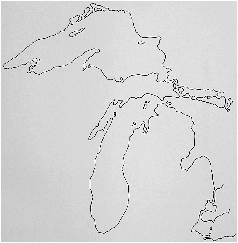
The second part of this work graphically presents, through a series of maps, the evolution of the counties. Territorial Michigan is represented in this series by an outline map of the Great Lakes. The State of Michigan (after 1837) is represented by maps with the outline of the present day counties superimposed upon them.
Appendix Two is a series of maps illustrating the evolution of townships within Shiawassee County, Michigan. This series of maps is included for the purpose of illustrating the manner in which townships evolved within a typical Michigan county.
A word of explanation should be given as to the steps followed and the terminology used in the organization of a county. The first step was the "setting off" of a certain area of land, usually sixteen congressional townships. This county was then given a name and "attached" to another county for judicial and/or taxation purposes; usually to the parent county. A county may, or may not, have had any permanent inhabitants at the time it was "set of from the parent county. As settlers moved in, and a need was felt for a local county government, the residents of a "set off county petitioned the state legislature for formal "organization" of the county. After a referendum was held, and a favorable vote received, the legislature then officially organized the county, giving it all the rights and responsibilities which were held by all previously established counties within the state.
The "set off" county had no official existence other than the fact that it had a name, was often shown on state maps, and contained a certain area of land which could not be incorporated into another county without a special act of the state legislature. The residents of the "set off" county were required to go to the county seat of the county to which they were attached for all matters of probate, land, taxation, marriage, and so on. Federal and state census enumerators usually included residents of a "set off county in the returns for the county to which they were "attached." For various reasons, "set off" counties were often detached from one county and attached to another county. Land and census records may, then, suggest that a resided in several counties during a given period of years. The data in this study suggests an alternative answer; the person did not migrate, the counties did.
It is hoped that the material included here will be of benefit to historical geographers, historians, teachers and genealogists.
COUNTY EVOLUTION IN MICHIGAN, 1790-1597
AISHCUM see Lake County.
ALCONA Set off in 1840 as Negwegon. Laws, 1840: 198. Name changed to Alcona in 1843. M.H.C.1 I: 302. Attached to Cheboygan in 1853. Laws, 1853: 19. Attached to Alpena in 1857. Laws, 1857: 162. Attached to Iosco in 1858. Laws, 1858: 16. Organized in 1869. Laws, 1869: 336.
ALGER Detached from Schoolcraft and organized in 1885, 1885: Acts 1885: 17.
ALLEGAN Set off in 1831. 1835: 58. Laws, 1831. Organized in 1835. Laws, 1835: 58.
ALPENA Set off in 1840 as Anomickee. Laws, 1840: 199. Name changed to Alpena in 1843. M.H.C., I: 98. Attached to Cheboygan in 1853. Laws, 1853: 19. Organized in 1857. Laws, 1857: 162.
ANOMICKEE see Alpena County.
ANTRIM Set off in 1840 as Megisee. Laws, 1840: 198. Name changed to Antrim in 1843. M.H.C., I: 263. Attached to Grand Traverse in 1853. Laws, 1853: 43. Organized in 1863. Laws. 1863: 119. In 1865, sections 1, 2, 11, and 12, and the portion of section 13 located to the east of Round Lake (Lake Skogemog in T28N, R9Wwere detached from Grand Traverse County and attached to Antrim. Laws, 1865: 528. In 1881 a small portion of land west of Torch Lake and Torch River and north of Round Lake (Lake Skogemog) was detached from Kalkaska and attached to Antrim. Local Acts, 1881: 102.
ARENAC Set off in 1831. Laws, 1831: 15. Attached to Saginaw in 1840. Laws, 1840: 200. Attached to Midland in 1858. Laws, 1858: 16. The county was removed in 1858 by the organization Bay County. M.H.C., I: 108. Detached from Bay County and reorganized in 1883. Laws, 1883: 25.
BARAGA Set off and organized in 1875 with the Sturgeon River as the boundary with Houghton County. Laws, 1875: 13. In 1885 the boundary line between Houghton and Baraga was defined as at present. Acts, 1885: 11.
1 Reports of Counties, Towns, and Districts, Pioneer Collections. Report of the Pioneer Society of the State of Michigan will be given in the text under the shortened title, M.H.C. (Michigan Historical Collections).
BARRY Set off in 1829. Terr. Laws, II: 735. Attached to St. Joseph County in 1829. Terr. Laws, 787. Attached to Kalamazoo County in 1830. Laws, 1830: 32. Organized in 1839. Laws, 1839: 17.
BAY Set off in 1857. The act was to be submitted to the people of Saginaw, Midland, and Arenac Counties on the first Monday of April, 1857. Laws, 1857: 438. The vote resulted in a legal battle which ended in the favor of Bay County. The county was organized in 1858. M.H.C., I: 108. In 1871 there was a slight readjustment of the boundary between Bay and Saginaw Counties. Laws, 1871: 194. Charity Islands were attached to Bay County from Huron County in 1879. Laws, 1879: 287. There was another readjustment of the boundary between Bay and Saginaw Counties in 1881. Laws, 1881: 343. Certain townships were detached in 1883 to form Arenac County, which see.
BENZIE Set off in 1863 to contain all the townships of Leelanau County which lie south of the south line of T28N. Attached to Grand Traverse County by the same law. Laws, 1863: 58. Organized in 1869. Laws, 1869, III: 1083.
BERRIEN Set off in 1829. Terr. Laws, II: 737. Attached to Cass County in 1829. Terr. Laws, II: 786. Organized in 1831. Laws, 1831: 902.
BLEEKER see Menominee County.
BRANCH Set off in 1829. Terr. Laws, II: 736. Attached to St. Joseph County in 1829. Terr. Laws, II: 745. Organized in 1833. M.H.C., I: 127 and Terr. Laws, III: 977.
BROWN Set off in 1818 by proclamation of Governor Lewis Cass to lie south and west of Michilimackinac County, extending south to Illinois. Terr. Laws, I: 327. The boundaries were changed in 1834. The county was to lie west of a line drawn due north from the center of Lake Michigan and south of the line between T11N and T12N, Green Bay base line. Terr. Laws, III: 1325.
CALHOUN Set off in 1829. Terr Laws, II: 736. Attached to St. Joseph County in 1829. Terr. Laws, II: 745. Attached to Kalamazoo County in 1830. Laws, 1830: 32. Organized in 1833. M.H.C., I: 128.
CASS Set off in 1829. Terr. Laws, II: 736. Organized in 1829. Terr. Laws, II: 744. In 1831 that part of Cass County lying east of the St. Joseph River (in the southeast corner of T8S, R13W) was attached to St. Joseph County. Laws, 1831: 39.
CHARLEVOIX Set off in 1840 as Keskkauko.2 Laws, 1840: 109. Name changed in 1843 to Charlevoix. M.H.C., I: 213. Attached to Emmet County in 1853. Laws, 1853: 15. Organized in 1869 to contain T32N, R4-7W; T33N, R4-9W; the south halves of T34N, R4-6W; and T34N, R7-8W. Laws, 1869, III: 1091. In 1895 the townships of Bear Creek and Resort and that portion of Springvale Township lying in T34N, R4W were detached from Charlevoix County and attached to Emmet County. The remaining portion of Springvale Township in T33N, R4W was attached to Chandler Township, Charlevoix County. Local Acts, 1895: 484.
CHEBOYGAN Set off in 1840. Laws, 1840: 199. Organized in 1853 with Wyandot County to form one county. Laws, 1853: 19.
CHEONQUET see Montmorency County.
CHIPPEWA Set off in 1826 to extend to the Mississippi River. Terr. Laws, II: 295. The county was organized by this same act, to take effect in 1827. Chippewa County was reduced in size in 1843. Laws, 1843: 201.
CLARE Set off in 1840 as Kaykakee County. Laws, 1840: 197. Attached to Saginaw County in 1840. Laws, 1840: 200. Name changed to Clare in 1843. M.H.C., I: 213. Attached to Midland County in 1858. Laws, 1858: 16. In 1869 eight townships from the western portion of the county (T17-20N, R5-6W) were attached to Mecosta County. Laws, 1869, II: 621. Organized in 1871. Laws, 1871, III: 59.
CLINTON Set off in 1831. Laws, 1831: 13. Attached ti Shiawassee County in 1837. Laws, 1837: 106. Organized in 1839. Laws, 1839: 15. The townships of North Shade, Fulton, and Washington (T9N, R2-4W) were attached to Clinton County from Gratiot County in 1845. Laws, 1845: 53. In 1847 three additional townships were attached from Gratiot (Elba, Hamilton, and Newark Townships; T9-10N, R1W and T10N, R3W). Laws, 1847: 56. The six townships were returned to Gratiot County in 1855. Laws, 1855: 12.
CRAWFORD Set off in 1840 as Shawono County. Laws, 1840: 198. Name changed to Crawford in 1843. M.H.C., I: 94. Attached to Cheboygan County in 1853. Laws, 1853: 19. Attached to Iosco County in 1858. Laws, 1858: 16. Attached to Antrim County in 1863. Laws, 1863: 119. Organized in 1879. Laws, 1879: 8.
2 A conflict exists as to the exact name of Charlevoix County as originally set off. It is given in the state law of 1840 as Keskkauko, but several other state documents, and Michigan Historical Collections, give the name as Reshkanko. Keskkauko appears to be the correct version.
DELTA Set off in 1843 to include what are now Menominee and the southern parts of Dickinson and Delta Counties. Laws, 1843: 202. Organized in 1861. Laws, 1861: 174 and 409. Big Summer, St. Martin's, Gull, and Poverty Islands were attached to Delta County in 1871. Laws, 1871, III: 219.
DICKINSON Set off and organized in 1891. Public Acts, 1891: 98.
EATON Set off in 1829. Terr. Laws, II: 735. Attached to St. Joseph County in 1829. Terr. Laws, II: 745. Attached to Kalamazoo County in 1830. Laws, 1830: 32. Organized in 1837. Laws, 1837: 9.
EMMET Set off as Tonedagana County in 1840. Laws, 1840: 199. Name changed to Emmet in 1843. M.H.C., I: 322. Organized in 1853 together with T37-39N, R4W from Cheboygan County. Laws, 1853: 15. Portions of three townships were attached to Emmet from Charlevoix County in 1895. Local Acts, 1895: 484.
GENESEE Set off in 1835 and attached to Oakland County. Terr. Laws, III: 1416. Organized in 1836. Acts, 1835: 66. In 1843,T6-9N, R8E from Lapeer County were attached to Genesee County. Laws, 1843: 189.
GLADWIN Set off in 1831. Laws, 1831: 14. Attached to Saginaw County in 1840. Laws, 1840: 200. Attached to Midland County in 1855. Laws, 1855: 231. Organized in 1875. Laws, 1875: 107.
GRATIOT Set off in 1831. Laws, 1831: 14. Attached to Saginaw County in 1836. Laws, 1836: 67. Six townships were detached from Gratiot and attached to Clinton County (which see) in 1845 and 1847. Laws, 1845: 53 and Laws, 1847: 56. Organized in 1855 with the townships which had been attached to Clinton. Laws, 1855: 12.
GOGEBIC Organized in 1887 from Ontonagon County. Local Acts, 1887: 23.
GRAND TRAVERSE Set off in 1840 as Omeena County. Laws, 1840: 198. In 1851 all of Omeena County, except T28N, R9-10N, was organized into the county of Grand Traverse. Laws, 1851: 172. In 1853 the remainder of Omeena was annexed by Grand Traverse County. Laws, 1853: 43.
HILLSDALE Set off in 1829. Terr. Laws, II: 736. Attached to Lenawee County in 1829. Terr. Laws, II: 745. Organized in 1835. Terr. Laws, III: 1362.
HOUGHTON Set off in 1843 and boundary described in 1845. Laws, 1845: 58. Organized in 1846. Laws, 1846: 286. Reorganized in 1848. Laws, 1848: 345. In 1853 the townships lying west of the line between R35W and R36W were annexed to Ontonagon County. In 1861 the boundary between Houghton and Marquette was re-adjusted. Laws, 1861: 173. In 1885 the boundary between Baraga and Houghton was defined. Acts, 1885: 11.
HURON Set off in 1840 and attached to Sagniaw County. Laws, 1840: 200. Attached to St. Clair County in 1844. Laws, 1844:112. In 1850 attached to Sanilac County. Laws 1850: 215, In 1853 certain townships from western portion of county were temporarily attached to Tuscola County. Laws, 1853: 113. Organized in 1859. Laws, 1859: 4. In 1879 Charity Islands were detached from Huron County and attached to Bay County. Laws, 1879: 287.
INGHAM Set off in 1829. Terr. Laws, II: 735. Attached to Washtenaw County in 1829. Terr. Laws, II: 787. Organized in 1838. Laws, 1838: 221.
IONIA Set off in 1831. Laws, 1831: 13. Attached to Kent County in 1835. Laws, 1835: 65. Organized in 1837. Laws, 1837: 97. In 1843 Towns 9 & 10 North, R6W were attached to Lyons Township, Ionia County. Laws, 1843: 200. These are now the townships of Evergreen and Bushnell, Montcalm County. Montcalm County was detached from Ionia County, and organized, in 1850. Laws, 1850: 144.
IOSCO Set off in 1840 as Kanotin County. Laws, 1840: 197. The name was changed to Iosco in 1843. M.H.C., I: 94. In 1853 was attached to Cheboygan County, and later in the same legislative session, was attached to Saginaw County. Laws, 1853: 19 and Laws, 1853: 45. Organized in 1857. Laws, 1857: 358. In 1867 the unorganized county of Ogemaw was attached to Iosco. Laws, 1867, II: 222. Ogemaw County was detached in 1875. Laws, 1875: 654.
IRON Set off and organized from Marquette and a portion of Menominee in 1885. Public Acts, 1885: 32. In 1891, Towns 45 and 46 North, Range 31-34 West were annexed from Marquette County. Public Acts, 1891: 106. The same year Towns 42-46 North, Range 28-30 West were detached from iron County and attached to the newly organized Dickinson County. Laws, 1891: 98.
ISABELLA Set off in 1831. Laws, 1831: 15. Attached to Saginaw County in 1840. Laws, 1840: 200. Attachment reaffirmed in 1853. Laws, 1853: 44. Attached to Midland County in 1855. Laws, 1855: 231. Organized in 1859. Laws, 1859: 318.
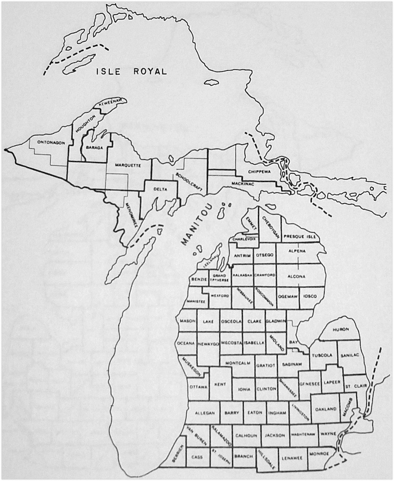
ISLE ROYAL Set off and organized from Keweenaw County in 1875. Laws, 1775: 18. Isle Royal County was disorganized and reattached to Keweenaw County in 1897. Public Acts, 1897.
JACKSON Set off in 1829. Terr. Laws, II: 735. Attached to Washtenaw County the same year. Terr. Laws, II 787. Organized in 1832. Acts of Legislative Council, 1832: 27 and Terr. Laws, III: 836.
KALKASKA Set off in 1840 as Wabassee County. Laws, 1840: 198. Name was changed to Kalkaska in 1843. M.H.C., I: 324. In 1853 was attached to Grand Traverse County. Laws, 1853: 43. In 1863 was attached to Antrim County. Laws, 1863: 119. Organized in 1871. Laws, 1871, III: 8. In 1881 that part of T28N, R8W lying west of Torch Lake and Torch River, and north of Round Lake (Lake Skogemog) was detached from Kalkaska County and attached to Antrim County. Local Acts, 1881: 102.
KANOTIN see Iosco County.
KAUTAWABET see Wexford County.
KAYKAKEE see Clare County.
KENT Set off in 1831. Laws, 1831: 13. Organized in 1836. Laws, 1836: 65. In 1840 Towns 9 and 10 North, Range 9-12 West (the northern two tiers of townships in present Kent County) were attached to Kent County from Michilimackinac County. Laws, 1840: 196.
KESKKAUKO see Charlevoix County.
KEWEENAW Set off and organized from Houghton County in 1861. Laws, 1861: 156. A mistake in the description of the county was made by the legislature in the preceeding law which was corrected in 1862. Laws, 1862: 3. Isle Royal was detached in 1875, re-attached in 1897. Laws, 1875: 18 and Public Acts, 1897: 75.
KNOX Set off by proclamation of Winthrop Sargent, secretary to Governor St. Clair, in 1790. St. Clair Papers, II: 166.
LAKE Set off in 1840 as Aishcum County. Laws, 1840: 196. Attached to Ottawa County the same year. Laws, 1840: 200. Name changed to Lake County in 1843. M.H.C., I: 94. Attached to Oceana County in 1851. Laws, 1851: 150. Attached to Mason County in 1855. Laws, 1855: 424. Attached to Newaygo County in 1857. Laws, 1857: 463. In 1867 Towns 17-20 North, Range 11 West were attached to Mecosta County. Laws, 1867, II: 925. In 1869 T17-20N, R11-12W were attached to Osceola County. Laws, 1869, II: 605. Organized in 1871 as originally set off. Laws, 1871, III: 714.
LAPEER Set off in 1822. Terr. Laws, I: 333. Attached to Oakland County by this same law. Organized in 1833. Laws, Extra Session, 1834-5: 54. In 1836 the townships lying north of Lapeer County to Lake Huron were attached. Laws, 1836: 67. In 1845 a small piece of territory was given to Tuscola County. Laws, 1845: 49. In 1855 other territory was given to Tuscola County. Laws, 1855: 313.
LEELANAU Set off in 1840 (to include the Manitou Islands) and attached to Michilimackinac County. Laws, 1840: 198. In 1853 was attached to Grand Traverse County. Laws, 1853: 43. Organized in 1863 to include all that part of Leelanau County which lay north of the south line of T28N. The townships of Leelanau County which lay south of this line were set off as Benzie County, which see. Laws, 1863: 56.
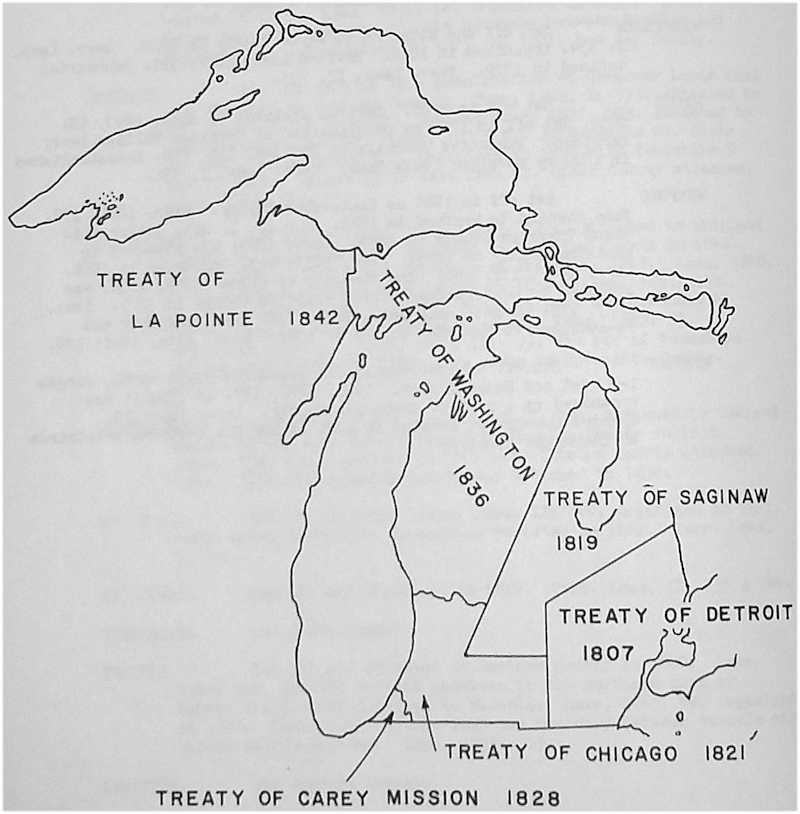
LENAWEE Set off in 1822 and attached to Monroe County. Terr. Laws, I: 335. Organized in 1826 and all territory to the west to which Indian title had been extinguished by the Treaty of Chicago was attached. Revised Laws, 1827: 591. In 1829 the territory gained by the Treaty of Carey Mission was attached. Terr. Laws, II: 709.
LIVINGSTON Set off in 1833, but was to remain for the time being a part of Shiawassee and Washtenaw Counties. Terr. Laws, III: 993. Organized in 1836. Laws, 1835: 65.
LUCE Set off from Machinac and Chippewa Counties in 1887 and organized. Laws, 1887: 84.
MACKINAC Laid out in 1818 as Michilimackinac, by proclamation of Governor Lewis Cass. Terr. Laws, I: 325. An 1840 law created a large number of counties in lower Michigan and only those townships north of T20N remained attached to Michilimackinac County. Laws, 1840: 200. Mackinac County was confined to the Upper Peninsula in 1843. Laws, 1843: 201. In 1887 the northern tier of townships were detached when Luce County was created. Laws, 1887: 84.
MACOMB Set off and organized in 1818. Terr. Laws, II: 796. In 1822 the boundaries were restated by Governor Lewis Cass. Terr. Laws, I: 332. In 1832 T5N, R14E and the east one-half , of T5N, R13E were attached to Macomb County. Terr. Laws, III: 926.
MANISTEE Set off in 1840. Laws, 1840: 197. Attached to the county of Michilimackinac until 1846 when it was attached to Ottawa County. Laws, 1846: 31. Attached to Oceana County in 1851. Laws, 1851: 150. Attached to Grand Traverse County in 1853. Laws, 1853: 43. Organized in 1855. Laws, 1855: 423. Cleon Township attached to Wexford County in 1873. Laws, 1873, III: 80. Cleon Township was reattached to Manistee County in 1881. Local Acts, 1881: 120.
MANITOU Set off and organized from Emmet County in 1855. Laws, 1855: 197. The organization law was repealed in 1895 and Manitou County was divided between Leelanau and Charlevoix Counties. Local Acts, 1895: 132.
MARQUETTE Set off and attached to Chippewa County in 1843. Laws, 1843: 202. In 1845 the north line of the county was brought down to the north line of T49N. Laws, 1845: 58. Attached to Houghton County in 1846. Laws, 1846: 286. Organized with Schoolcraft and Ontonagon Counties into one judicial district and attached to Houghton County in 1848. Laws, 1848: 345. Organized in 1851 to include "all that portion of the state . . . between ranges twenty-three and twenty-four west, the north boundary of township forty-one, the line between ranges thirty-seven and thirty-eight west, and the north boundary of township forty-nine." Laws, 1851: 142. In 1861 the townships between the city of Marquette and Lake Superior on the north were attached to Marquette County from Houghton County. Laws, 1861: 556. In 1873 Town 41 north, Range 32 west was attached to Marquette County. Laws, 1873, III: 75. In 1875 Towns 44-47 north, Range 23 west, on the east side of the county, were attached. Local Acts, 1875: 233. In 1891 certain townships were given to Iron County, which see. Laws, 1891: 106.
MASON Set off in 1840 as Notipekago County and attached to Ottawa County. Laws, 1840: 196 & 200. Name changed to Mason in 1843. M.H.C., I: 303. Attached to Oceana County in 1851. Laws, 1851: 150. Organized in 1855. Laws, 1855: 423.
MECOSTA Set off in 1840. Laws, 1840: 196. Attached to Kent. Laws, 1840: 200. In 1857 was attached to Newaygo County. Laws, 1857: 468. The township of Pierson, containing four congressional townships, was attached to Montcalm County from Mecosta in 1857. Laws, 1857: 468. Organized in 1859. Laws, 1859: 257. The township of Pierson was permanently attached to Montcalm County in 1859. Laws, 1859: 261.
MEGISEE see Antrim County.
MENOMINEE Set off in 1861 as Bleeker County. Laws, 1861: 448. Organized in 1863 as Menominee County. Laws, 1863: 297. In 1873 fractional T41N, R31W was attached. Laws, 1873, III: 85. In 1875 fractional T41N. R33W was attached. Local Acts, 1875: 21. In 1877 the boundaries of the county were redefined. Acts, 1877: 59. In 1885 T41N, R31-33W were given to Iron County. Public Acts, 1885: 32. In 1891 certain townships were detached from Menominee County to form Dickinson County. Public Acts, 1891: 98.
MIDLAND Set off in 1831. Laws, 1831: 14. Attached to Saginaw County in 1836. Laws, 1836: 67, and Laws 1840: 200. A law was passed for organization of the county in 1850 (Laws, 1850: 182), but nothing was done toward organization until 1855 when another law was passed providing for the first election. Laws, 1855: 48. In 1873 a law was passed which corrected an error in the description of the county boundaries which had been made in the 1831 law. Acts, 1873, III: 85.
MIKENAUK see Roscommon County.
MISSAUKEE Set off in 1840. Laws, 1840: 197. In 1853 was attached to Grand Travers County. Laws, 1853: 43. Attached to Wexford County in 1869. Acts, 1871, III: 44.
MONROE Set off in 1817 by proclamation of Governor Lewis Cass. Terr. Laws, I: 331. All the territory to which Indian title had been extinguished was attached to Monroe County in 1822. Terr. Laws, I: 335.
MONTCALM Set off in 1831. Laws, 1831: 14. Attached to Ionia County in 1840. Laws, 1840: 200 and Laws, 1845: 51. Organized in 1850. Laws, 1850: 114. In 1859 the township of Pierson, containing four congressional townships, was annexed from Mecosta County. Laws, 1859: 261.
MONTMORENCY Set off in 1840 as Cheonoquet County. Laws, 1840: 199. Name changed to Montmorency in 1843. M.H.C., I: 94. Attached to Cheboygan County in 1853. Laws, 1853: 19. Attached to Alpena County in 1857. Laws, 1857: 162. Organized in 1881 along with the townships of Montmorency, Rust, and Briley. Public Acts, 1881: 160.
MUSKEGON Set off and organized in 1859. Acts, 1859: 94.
NEGWEGON see Alcona County.
NEWAYGO Set off in 1840. Laws, 1840: 196. Attached to Kent County in 1840. Laws, 1840: 200. Township 11 north, Range 14 west (Bridgeton Township) was attached to Ottawa County in 1845. Laws, 1845: 31. Newaygo County was attached to Oceana County in 1851. Laws, 1851: 150. No mention is made in this law (1851) as to the status of Bridgeton Township. Newaygo County was organized in 1851 with its present boundaries. Laws, 1851: 305.
NOTIPEKAGO see Mason County.
OAKLAND Set off by a proclamation of Governor Lewis Cass in 1819. Terr. Laws, II: 798. All the territory gained under the Treaty of Saginaw in 1819 was attached to Oakland County in 1822. Terr. Laws, II: 802. Organized in 1821. Terr. Laws, I: 332.
OCEANA Set off in 1831 in territory now included in Kent, Montcalm, Newaygo, and Muskegon Counties, consisting of Townships 9-12 north, Ranges 9-12 west and T11-12W, R13W., entirely different from its present location. Laws, 1831: 14. Set off in 1840 in its present location. Laws, 1840: 196. Attached to Ottawa in 1840. Laws, 1840: 200. Organized in 1851 (Laws, 1851: 150) and re-organized in 1855 when Manistee and Mason Counties were organized. Laws, 1855:423.
OGEMAW Set off in 1840 as Townships 21-24 north, Ranges 1-4 west. Laws, 1840: 197. Attached to Cheboygan County in 1853. Laws, 1853: 19. Attached to Iosco County in 1858. Laws, 1858: 16 and Laws, 1861: 121. Incorporated into Iosco County in 1867 and Ogemaw County ceased to exist. Laws, 1867: 222. The location of the county was correctly stated in 1873 as Ranges 1-4 east, it was set off, and attached to Iosco County. Laws, 1873, III: 85. Organized in 1875. Laws, 1875: 129.
OKKUDDO see Otsego County.
ONTONAGON Set off in 1843 and attached to Chippewa. Laws, 1843: 202. The boundary was restated in 1845 omitting Isle Royale. Laws, 1845: 58. Attached to Houghton County in 1846. Laws, 1846: 286. Organized in 1848. Laws, 1848: 345. The western two tiers of townships of Houghton County were attached to Ontonagon County in 1853. Laws, 1853: 3.
OSCEOLA Set off in 1840 as Unwattin County and attached to Ottawa County. Laws, 1840: 197 & 200. Name changed to Osceola County in 1843. M.H.C., I: 324. Attached to Mason County in 1855. Laws, 1855: 423. Attached to Newaygo County in 1857. Laws, 1857: 463. Attached to Mecosta County in 1859. Laws, 1859: 257. Organized in 1869. Laws, 1869, II: 487. (see also Lake County.)
OSCODA Set off in 1840. Laws, 1840: 198. Attached to Cheboygan County in 1853. Laws, 1853: 19. Attached to Alpena County in 1857. Laws, 1857: 162. Attached to Iosco County in 1858. Laws, 1858: 16. Attached to Alcona County "from Alpena County" in 1869. Laws, 1869, II: 336. Detached from Alcona and organized in 1881. Acts, 1881: 16.
OTSEGO Set off in 1840 as Okkuddo County. Laws, 1840: 198. Name changed to Otsego County in 1843. M.H.C., I: 94. Attached to Cheboygan in 1853. Laws, 1853: 19. Attached to Alpena in 1858. Laws, 1858: 16. Attached to Antrim County in 1863. Laws, 1863: 119. Organized in 1875 with Townships 29-31 north, Ranges 1-4 west and Township 32 north, Ranges 1-3 west. Township 32 north, Range 4 west remained in Charlevoix County to which it was attached in 1869. Laws, 1875: 28.
OTTAWA Set off in 1831. Laws, 1831: 13. Attached to Kent County in 1835. Laws, 1835: 65. Organized in 1837. Laws, 1837: 8. Township 11 north, Range 14 west (Bridgeton Township, Newaygo County) was attached in 1845 (Laws, 1845: 31) and detached in 1851 when Newaygo County was organized.
PRESQUE ISLE Set off in 1840. Laws, 1840: 199. Attached to Cheboygan in 1853. Laws, 1853: 19. In 1857 the territory lying east of R4E was attached to Alpena County. Laws, 1857: 162. Attached to Alpena in 1858. Laws, 1858: 16. Organized in 1871. Laws, 1871, III: 129. T37N, R2E attached to Presque Isle from Cheboygan in 1873. Laws, 1873, III: 85. Re-organized in 1875. Laws, 1875: 118.
ROSCOMMON Set off in 1840 as Mikenauk County. Laws, 1840: 199. Name was changed to Roscommon in 1843. M.H.C., I: 94. Attached to Cheboygan County in 1853. Laws, 1853: 19. Attached to Midland County in 1858. Laws, 1858: 16 and Laws, 1873, III: 85. Organized in 1875. Laws, 1875: 34.
SAGINAW Set off in 1822 by a proclamation of Governor Lewis Cass and attached to Oakland County. Terr. Laws, I: 334. Boundaries stated in 1831. Laws, 1831: 14. Organized in 1835. Acts, Extra Session, 1834-35: 78. The boundary between Saginaw and Bay Counties was adjusted in 1875 and 1881. See Bay County.
SANILAC Set off in 1822 by a proclamation of Governor Lewis Cass and attached to Oakland County. Terr. Laws, I: 333. Attached to St. Clair County in 1827. Revised Laws, 1827: 593. Attached to Lapeer County in 1836. Laws, 1836: 67. Attached to St. Clair in 1840. Laws, 1840: 112. Organized in 1848 with Townships 9 and 10 north, Ranges 13-17 east from St. Clair County attached. Laws, 1848: 344.
SCHOOLCRAFT Set off in 1843. Laws, 1843: 202. Attached to Chippewa County by this same act. Attached to Houghton County in 1846. Laws, 1846: 286. The boundaries were stated in 1848. Laws, 1848: 346. Attached to Marquette County in 1851. Laws, 1851: 142. In 1862 Townships 39-41 north, Range 16 west and Township 41 north, Ranges 13-15 west were attached. Laws, 1862: 53. Organized in 1871. Laws, 1871, III: 99. The row of townships on the west (T44-47N, R23W) were given to Marquette County. Local Acts, 1875: 233.
SHIAWASSEE Set off in 1822. Terr. Laws, I: 334. Attached to Oakland County by the same act. Attached to Genesee County in 1836. Acts, 1836: 66. Organized in 1837 with Clinton County attached. Laws, 1837: 106. Clinton County was detached in 1839.
ST. CLAIR Set off in 1820. Terr. Laws, II: 800. Organized in 1821. Terr. Laws, 1820: 446. Boundaries restated in 1822. Terr Laws, I: 332.
ST. JOSEPH Set off and organized in 1829. Terr. Laws, II: 736 & 744.
TONEDAGANA see Emmet County.
TUSCOLA Set off and attached to Saginaw County in 1840. Laws, 1840: 200. In 1845 certain sections in the northern part of Lapeer County were attached to Tuscola. Laws, 1845: 49. Organized in 1850. Laws, 1850: 45. In 1855 the boundary between Tuscola and Lapeer was re-defined. Laws, 1855: 313.
UNWATTIN see Osceola County.
VAN BUREN Set off and attached to Cass County in 1829. Terr. Laws, II: 736 & 744. Re-attached to Cass County in 1834. Laws, 1834: 169. Organized in 1837. Laws, 1837: 97.
WABASSEE see Kalkaska County.
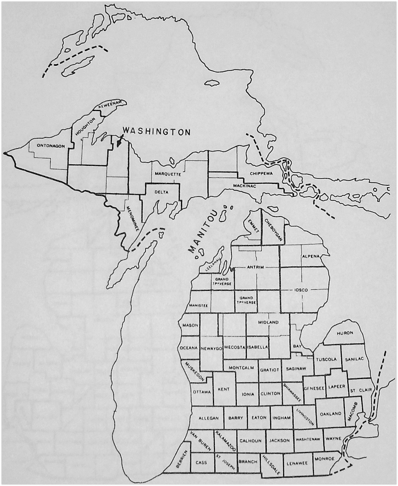
WASHINGTON Organized February 15, 1867 with the city of Negaunee as the county seat. Laws, 1867: 39. A lawsuit followed in which the court found in favor of the plaintiff, nullifying the act of organization. The County of Washington existed for only a short period of time and was never truly "organized". See map on page 32 for location of Washington County.
WASHTENAW Set off and attached to Wayne County in 1822. Terr. Laws, I: 334. Organized in 1826. Revised Laws, 1827: 591. Boundaries defined in 1829. Terr. Laws, II: 735.
WAYNE Set off in 1796. Revised Statutes of Ohio, 1890, II: 2036. Set off in 1803 by proclamation of Governor William Henry Harrison. Executive Journals of Indiana, III: 114. Re-established in 1822 by Governor Lewis Cass. Terr. Laws, I: 331.
WEXFORD Set off in 1840 as Kautawabet County. Laws, 1840: 197. Name changed to Wexford in 1843. M.H.C., I: 212. Attached to Grand Traverse County in 1853. Laws, 1853: 43. Attached to Manistee County in 1855. Laws, 1855: 423. Organized in 1869. Laws, 1869, III: 1085. The township of Cleon (T24N, R13W) was attached to Wexford County from Manistee County in 1873. Laws, 1873, III: 80 and Local Acts, 1875: 726. Cleon Township was re-attached to Manistee County in 1881. Local Acts, 1881: 120.
WYANDOT Set off in 1840 containing Townships 33-36 north, Ranges 1-3 west and Range 1 east. Laws, 1840: 199. In 1853 it was organized as a part of Cheboygan County. Laws, 1853: 19. Wyandot County was located in what is now the southern two-thirds of Cheboygan County.
Michigan Counties 1790
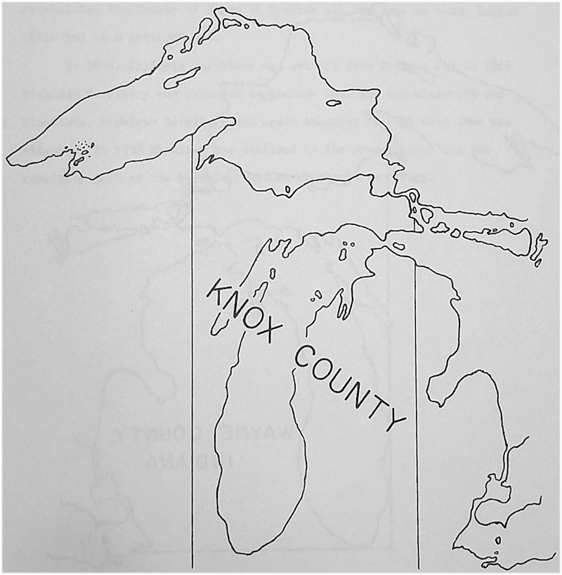
The area to the east of Knox County was still under the military control of the British at this time.
Michigan Counties 1803
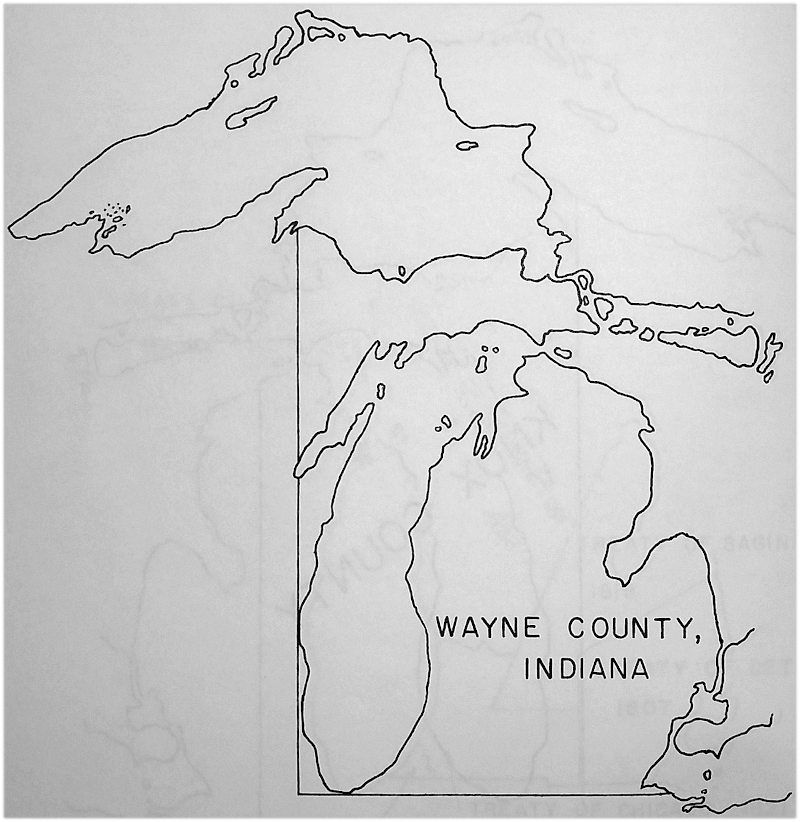
Wayne County as set off by Governor William Henry Harrison in 1803. The Territory of Michigan came into existence in 1805.
When William Hull became governor of Michigan Territory in 1805 he rearranged the territory into districts of his own choosing and Wayne County ceased to exist. When Lewis Cass became governor in 1815, he re-established the County of Wayne to include all the area to which Indian title had been extinguished.
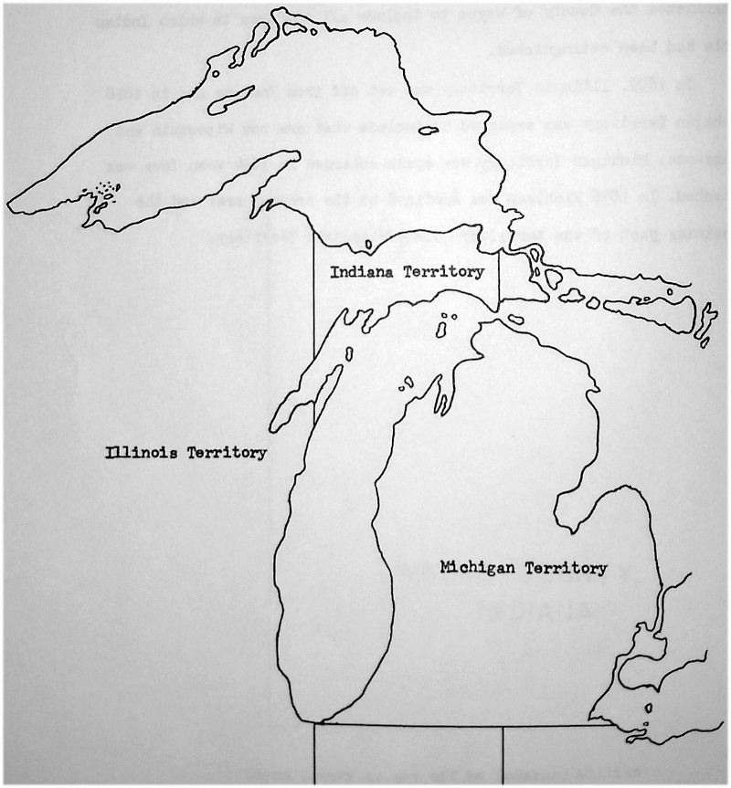
In 1809, Illinois Territory was set off from Indiana and in 1818 Michigan Territory was expanded to include what are now Wisconsin and Minnesota. Michigan Territory was again enlarged in 1834 when Iowa was attached. In 1836 Michigan was confined to its present area and the remaining part of the territory became Wisconsin Territory.
Michigan Counties 1809-1815
Michigan Counties 1818
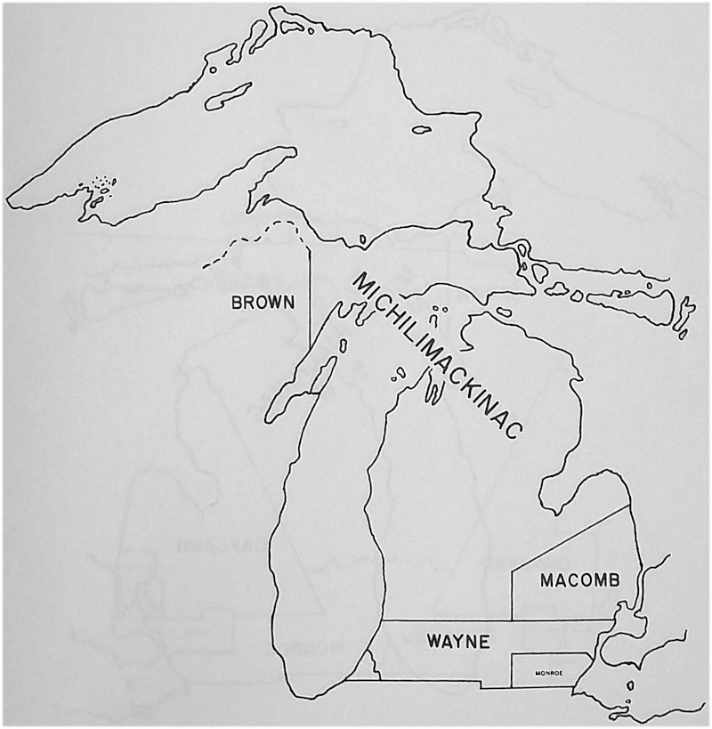
Brown County, as set off and organized, was to lie to the south of the headwaters of the rivers that flow into Lake Superior.
Michigan Counties 1822
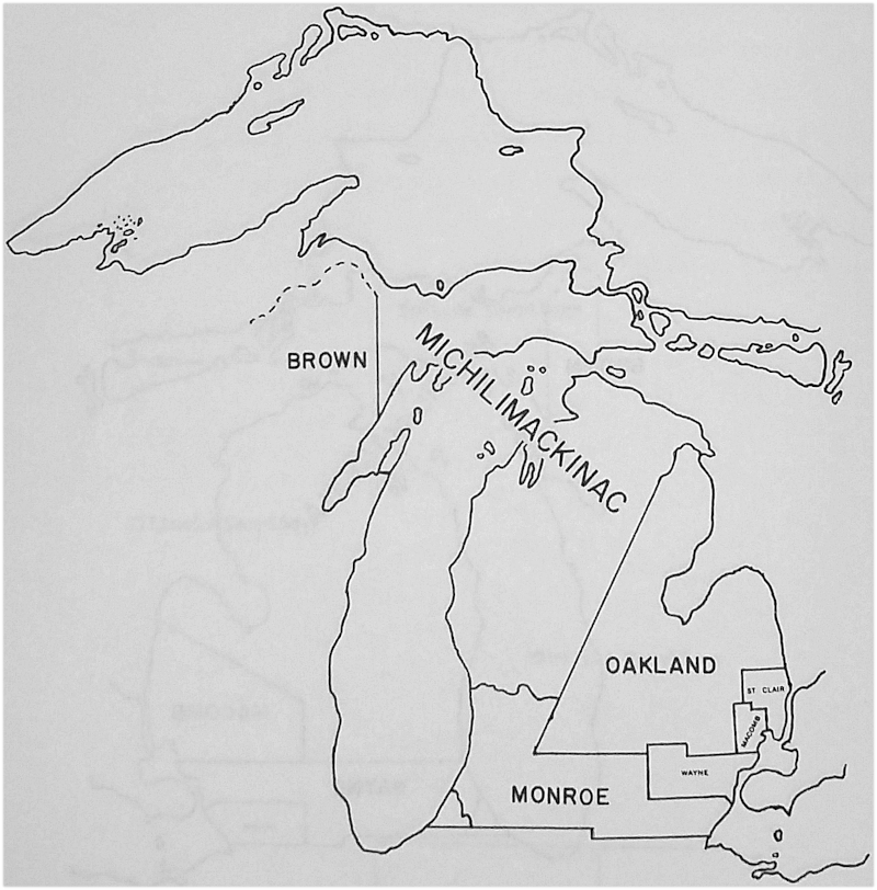
Oakland County was set off in 1819 to include the region acquired under the treaty of Saginaw (Terr. Laws, II: 802). The county was organized in 1821. In 1822 the territory gained under the treaty of Chicago in 1821 was attached to Monroe County. (Terr. Laws, I: 335).
Michigan Counties 1828
Lenawee County was organized in 1826 and the lands gained under the treaty of Chicago were attached. (Revised Laws, 1827: 591). In 1829 the territory gained under the treaty of Carey Mission was attached. (Terr. Laws, II: 709)
Michigan Counties 1830
Michigan Counties 1832
Michigan Counties 1836
Michigan Counties 1840
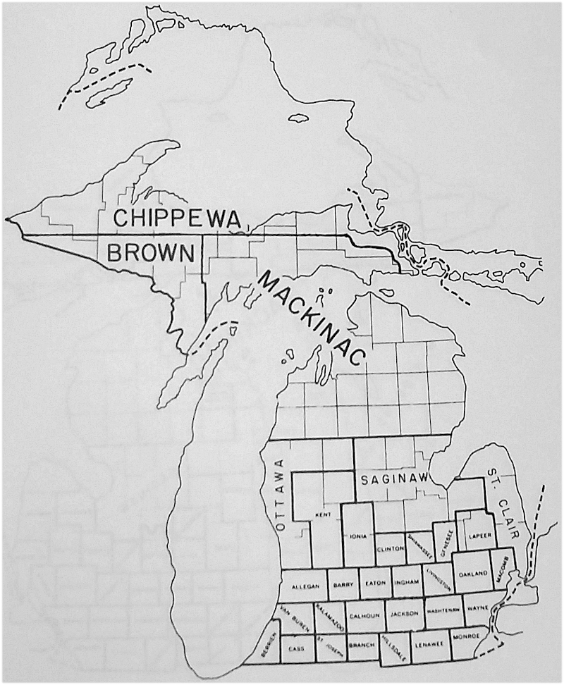
Huron County was attached to Saginaw County for judicial purposes, to St. Clair County for taxation purposes. (Laws, 1840: 112 & 200). Gratiot, Midland, Tuscola, Isabella, Gladwin, Arenac, and Kaykakee (Clare) were attached to Saginaw County for judicial purposes. (Laws, 1840: 200).
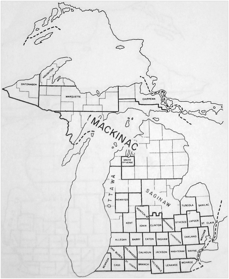
Michigan Counties 1852
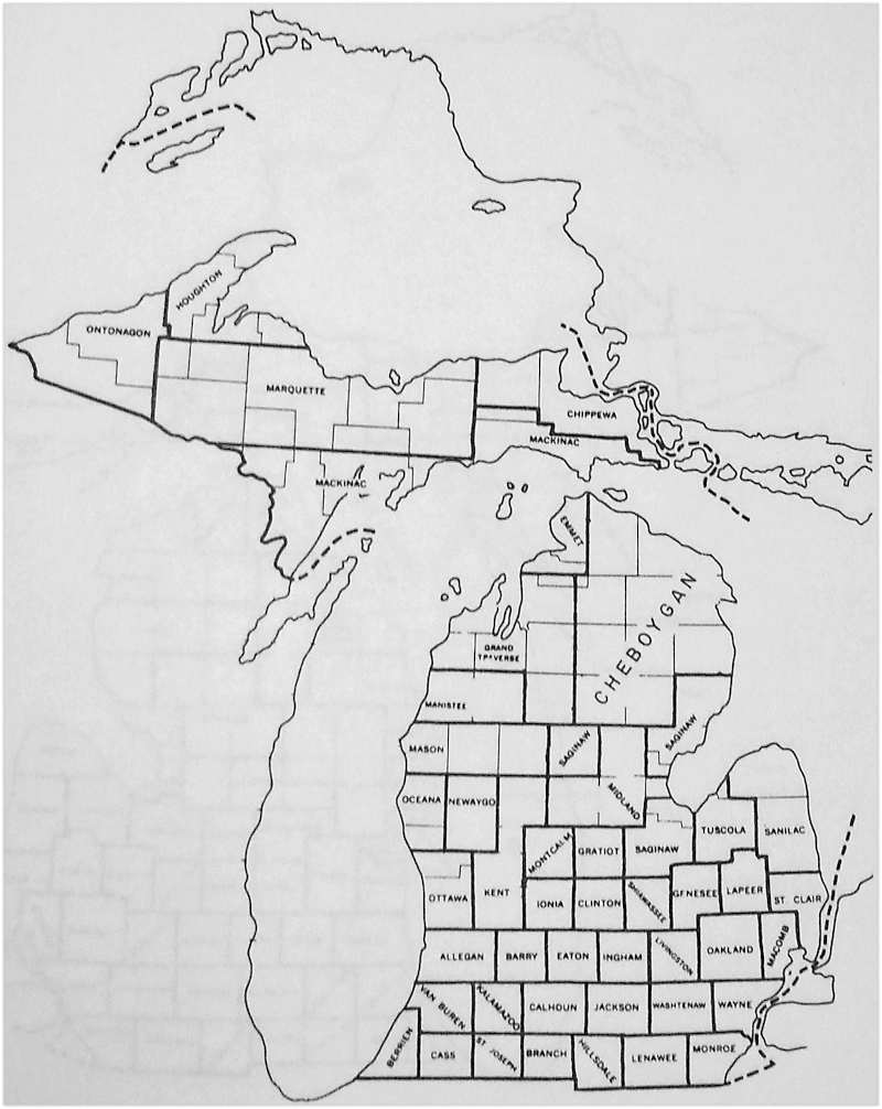
Michigan Counties 1856
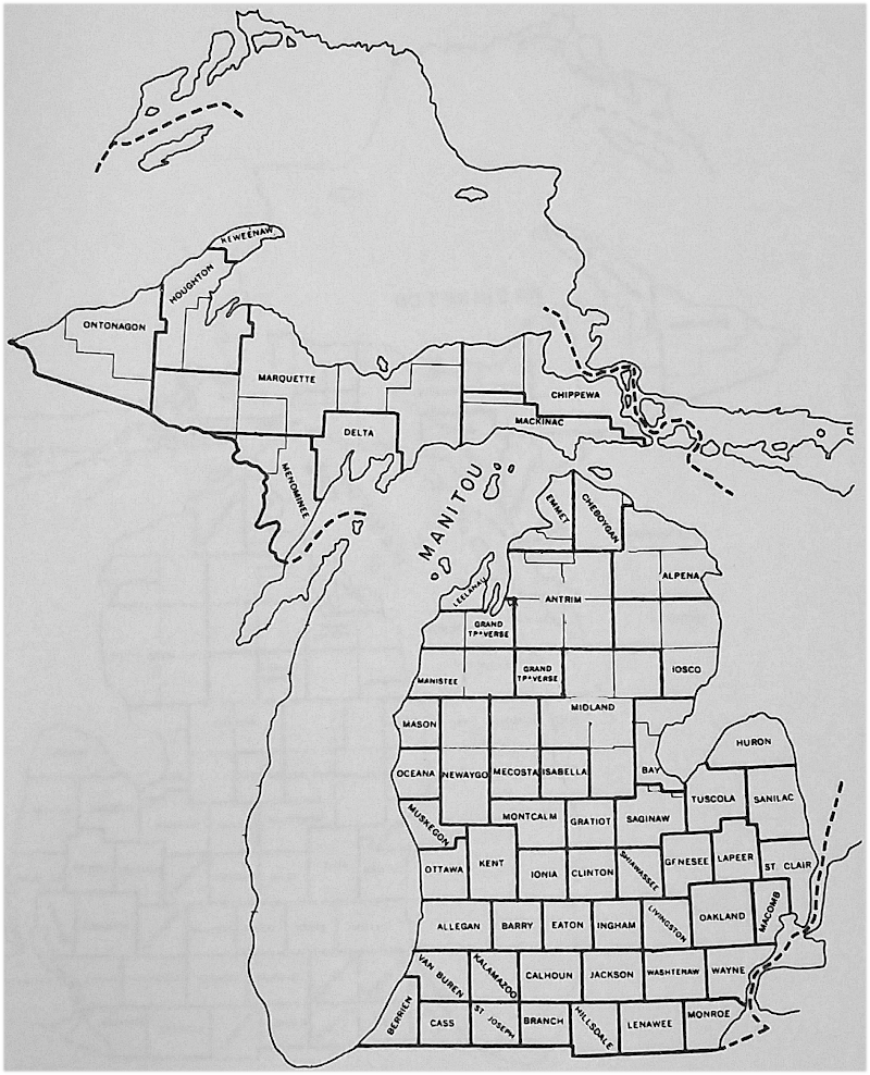
Michigan Counties 1860

Michigan Counties 1864
Michigan Counties 1867
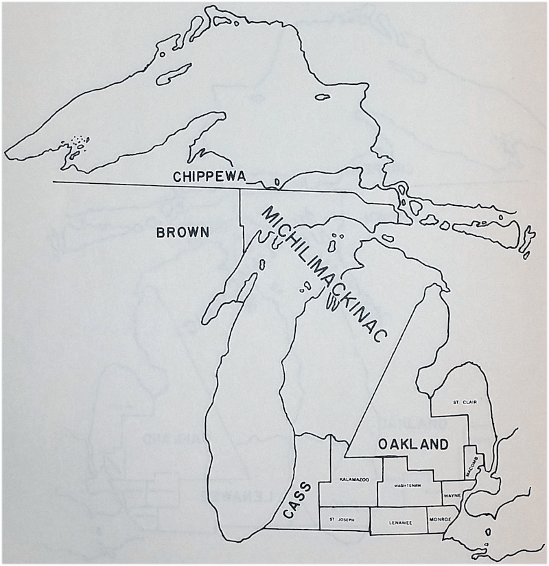
Michigan Counties 1872
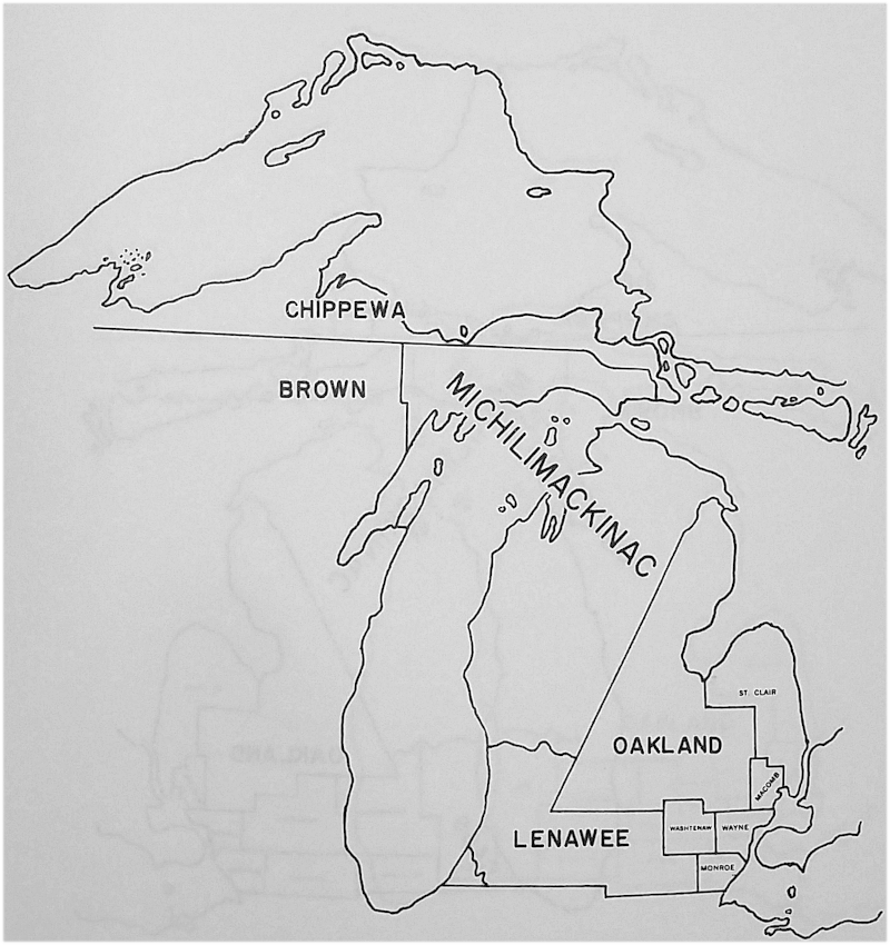
Michigan Counties 1876
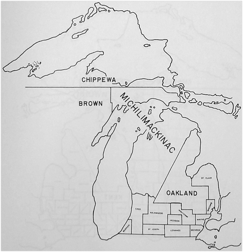
Michigan Counties 1885
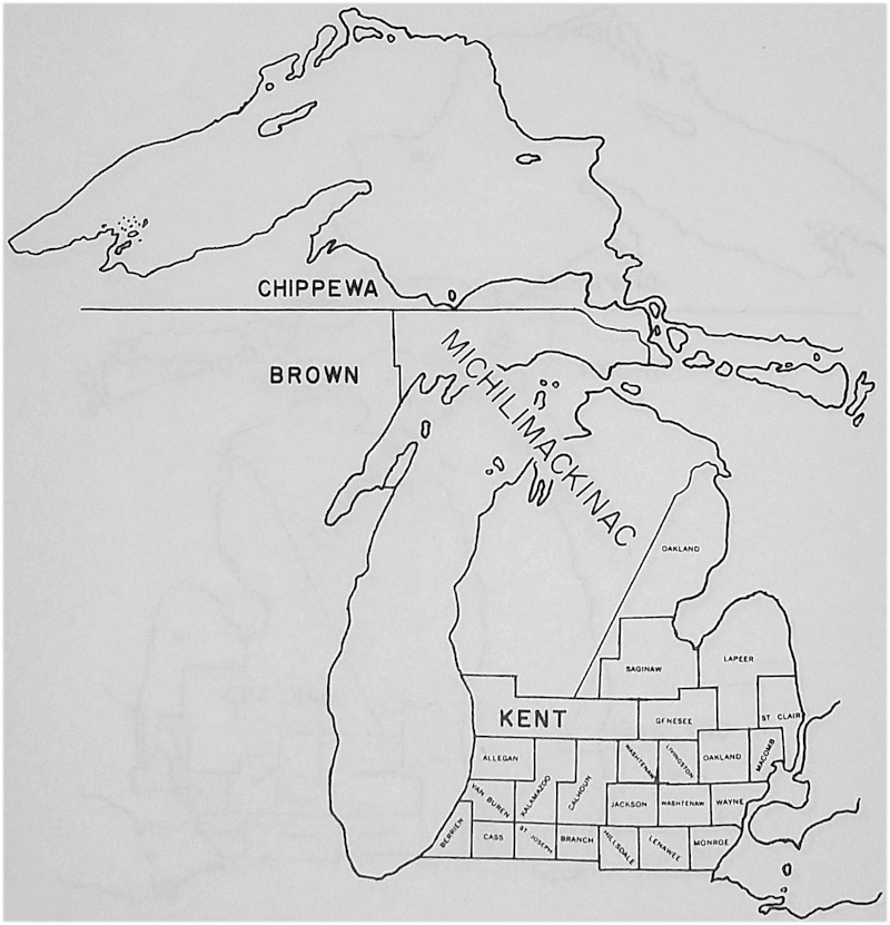
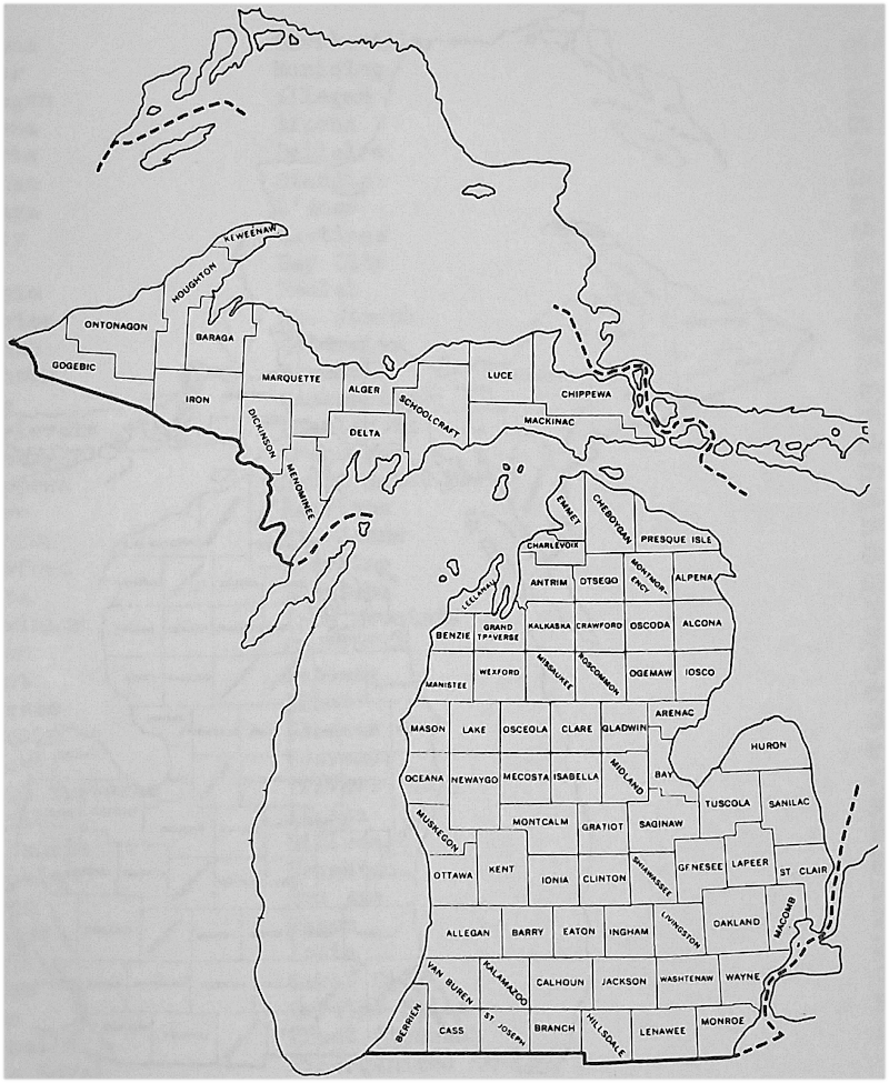
Michigan Counties 1895
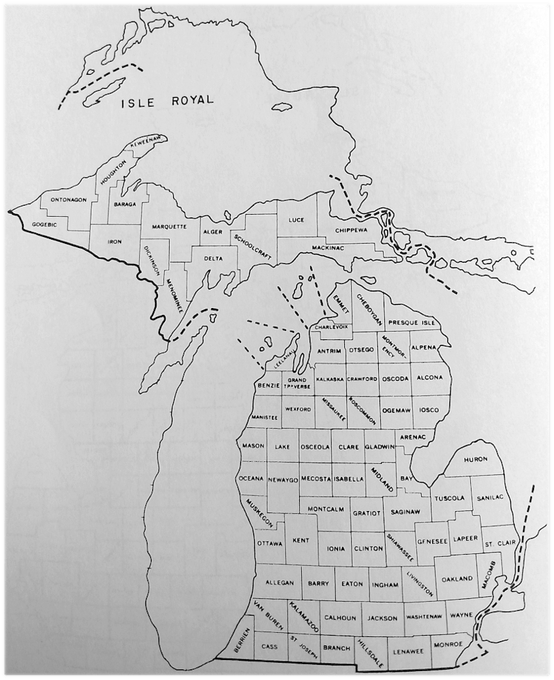
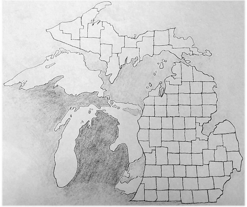
Michigan Counties 1897-present
Michigan Counties Index
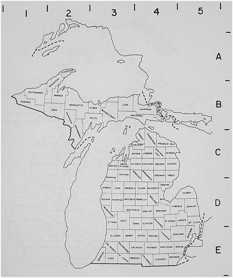
Michigan Counties Index
|
Name |
County
Seat |
Map
Coordinates |
|
Alcoa |
Harrisville |
C5 |
|
Alger |
Munising |
B3 |
|
Allegan |
Allegan |
E3 |
|
Alpena |
Alpena |
C5 |
|
Antrim |
Bellaire |
C4 |
|
Arenac |
Standish |
D4 |
|
Baraga |
L'Anse |
B2 |
|
Barry |
Hastings |
E4 |
|
Bay |
Bay City |
D4 |
|
Benzie |
Beulah |
C3 |
|
Berrien |
St. Joseph |
E3 |
|
Branch |
Coldwater |
E4 |
|
Calhoun |
Marshall |
E4 |
|
Cass |
Cassopolis |
E3 |
|
Charlevoix |
Charlevoix |
C4 |
|
Cheboygan |
Cheboygan |
C4 |
|
Chippewa |
Sault Saint Marie |
B4 |
|
Clare |
Harrison |
D4 |
|
Clinton |
St. Johns |
D4 |
|
Crawford |
Grayling |
C4 |
|
Delta |
Escanaba |
B3 |
|
Dickinson |
Iron Mountain |
B3 |
|
Eaton |
Charlotte |
E4 |
|
Emmet |
Petosky |
C4 |
|
Genesee |
Flint |
D5 |
|
Gladwin |
Gladwin |
D4 |
|
Gogebic |
Bessemer |
B1 |
|
Grand Traverse |
Traverse City |
C3 |
|
Gratiot |
Ithaca |
D4 |
|
Hillsdale |
Hillsdale |
E4 |
|
Houghton |
Houghton |
B2 |
|
Huron |
Bad Axe |
D5 |
|
Ingham |
Mason |
E4 |
|
Ionia |
Ionia |
D4 |
|
Iosco |
Tawas City |
C5 |
|
Iron |
Crystal Falls |
B2 |
|
Isabella |
Mount Pleasant |
D4 |
|
Isle Royal |
disorganized in 1897 |
|
|
Jackson |
Jackson |
E4 |
|
Kalamazoo |
E4 |
|
|
Kalkaska |
Kalkaska |
C4 |
|
Kent |
Grand Rapids |
D4 |
|
Keweenaw |
Eagle River |
A2 |
|
Lake |
Baldwin |
D3 |
|
Lapeer |
Lapeer |
D5 |
|
Leelanau |
Leland |
C3 |
|
Lenawee |
Adrian |
E4 |
|
Livingston |
Howell |
E4 |
|
Luce |
Newberry |
B3 |
|
Mackinac |
St. Ignace |
B4 |
|
Macomb |
Mount Clemens |
E5 |
|
Manistee |
Manistee |
C3 |
|
Manitou |
disorganized in 1895 |
|
|
Marquette |
Marquette |
B2 |
|
Mason |
Ludington |
D3 |
|
Mecosta |
Big Rapids |
D4 |
|
Menominee |
Menominee |
C2 |
|
Midland |
Midland |
D4 |
|
Missaukee |
Lake City |
C4 |
|
Monroe |
Monroe |
E5 |
|
Montcalm |
Stanton |
D4 |
|
Montmorency |
Atlanta |
C4 |
|
Muskegon |
Muskegon |
D3 |
|
Newaygo |
White Cloud |
D3 |
|
Oakland |
Pontiac |
E5 |
|
Oceana |
Hart |
D3 |
|
Ogemaw |
West Branch |
C4 |
|
Ontonagon |
Ontonagon |
B1 |
|
Osceola |
Reed City |
D4 |
|
Oscoda |
Mio |
C4 |
|
Otsego |
Gaylord |
C4 |
|
Ottawa |
Grand Haven |
D3 |
|
Presque Isle |
Rogers City |
C4 |
|
Roscommon |
Roscommon |
C4 |
|
Saginaw |
Saginaw |
D4 |
|
St. Clair |
Port Huron |
D5 |
|
St. Joseph |
Centreville |
E4 |
|
Sanilac |
Sandusky |
D5 |
|
Schoolcraft |
Manistique |
B3 |
|
Shiawassee |
Corunna |
D4 |
|
Tuscola |
Caro |
D5 |
|
Van Buren |
Paw Paw |
E3 |
|
Washtenaw |
Ann Arbor |
E4 |
|
Wayne |
Detroit |
E5 |
|
Wexford |
Cadillac |
C3 |
Township Evolution in Shiawassee County
1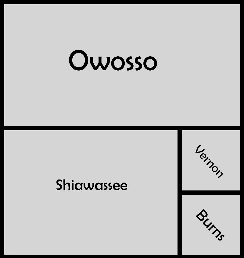
13 March 1837 - 6 March 1838
2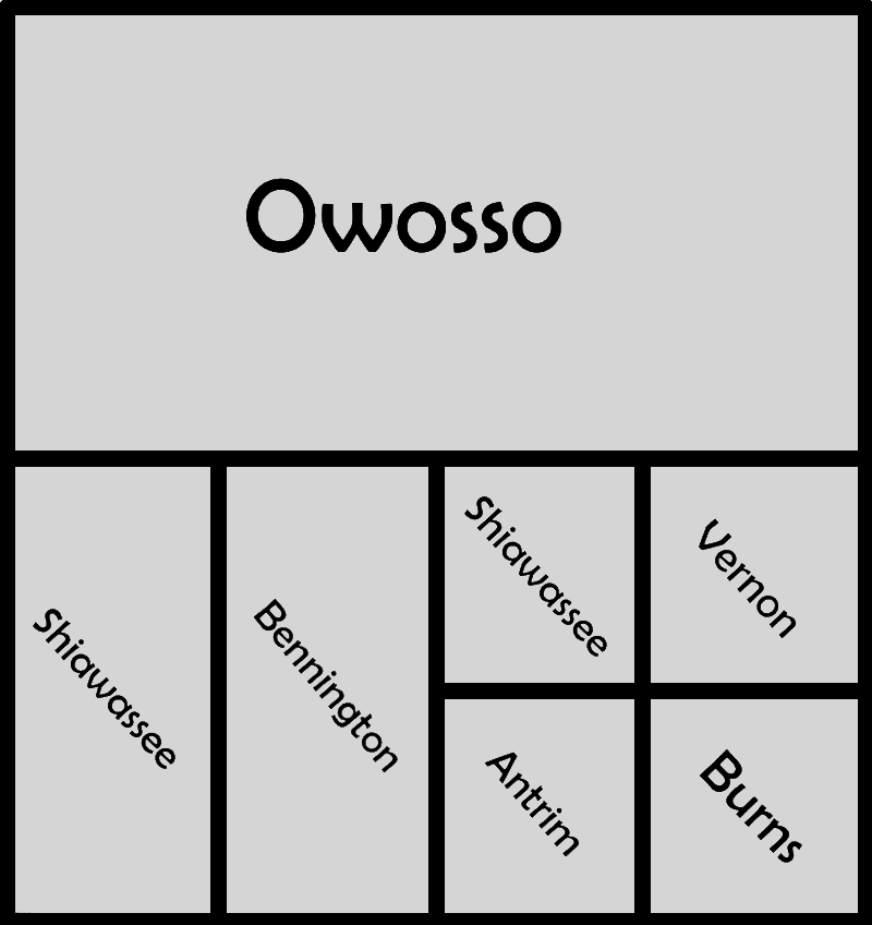
6 March 1838 - 2 April 1838
3
2 April 1838 - 21 March 1839
SCALE 1:250,000. Maps drawn for Geography 426, Michigan State University - May 1970, Richard W. Welch.
4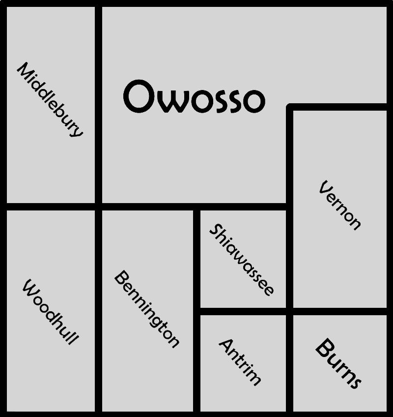
21 March 1839 - 22 March 1839
5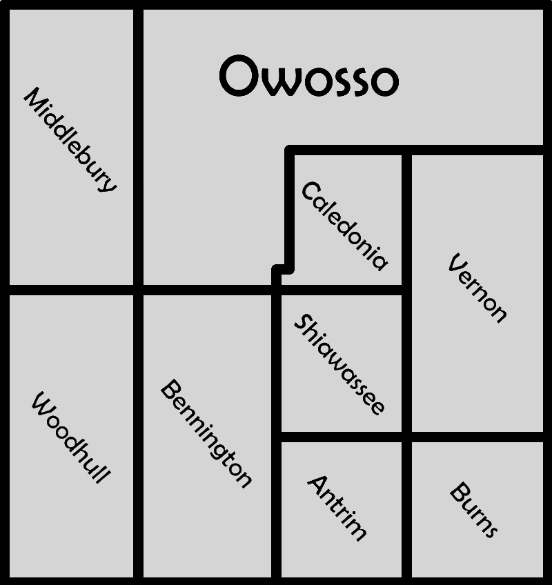
22 March 1839 - 15 March 1841
6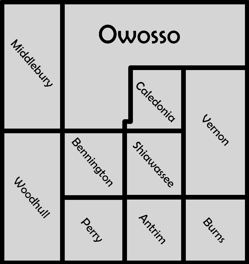
15 March 1841 - 20 March 1841
7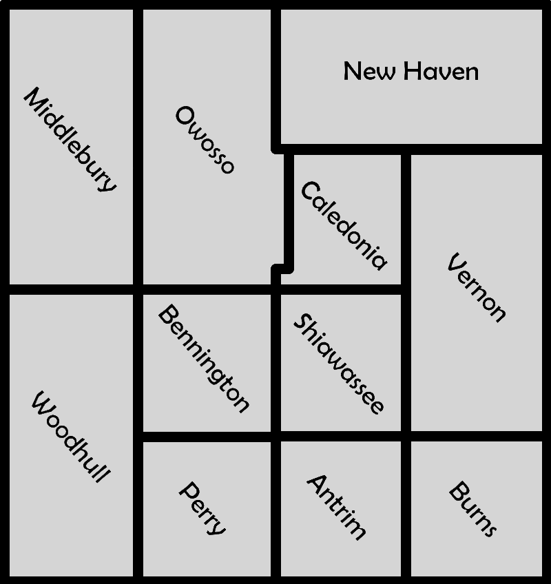
20 March 1841 - 16 February 1842
8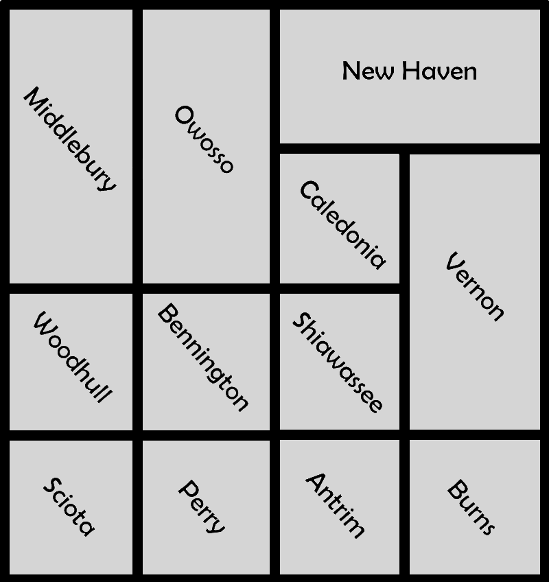
16 February 1842 - 9 March 1843
9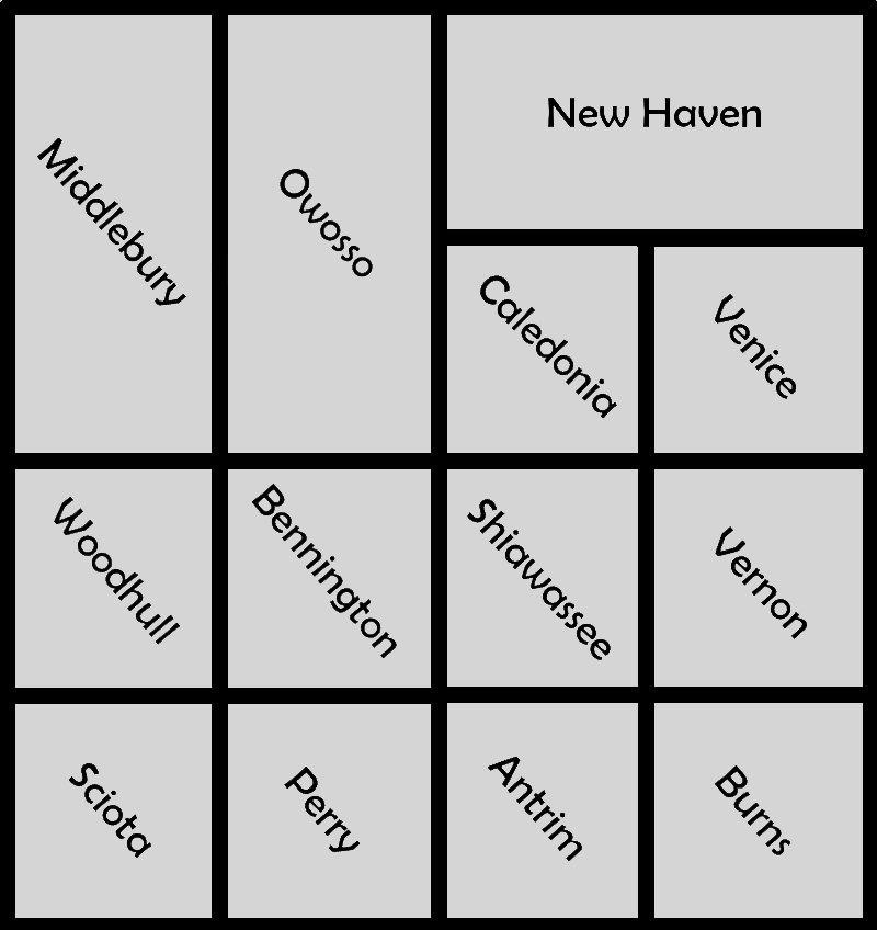
9 March 1843 - 28 March 1850
10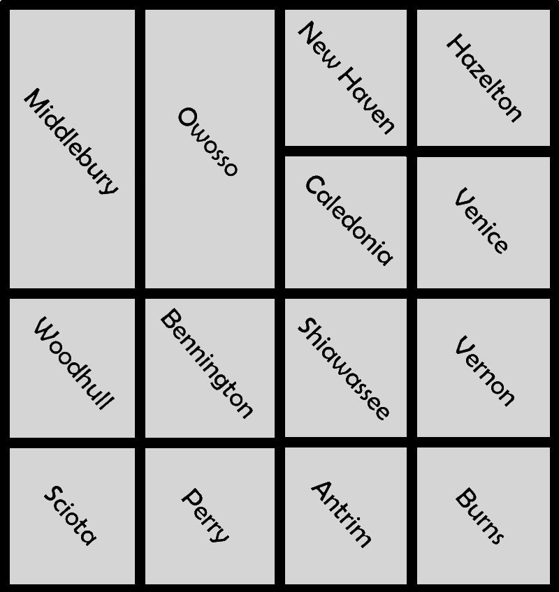
28 March 1850 - 31 March 1850
11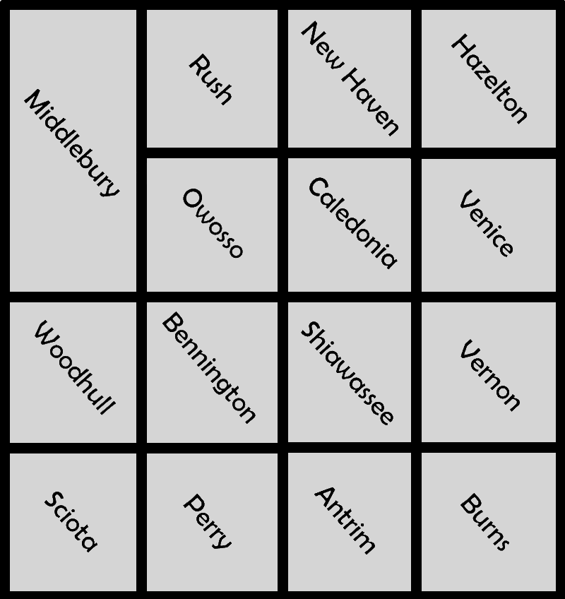
31 March 1850 - 4 January 1854
12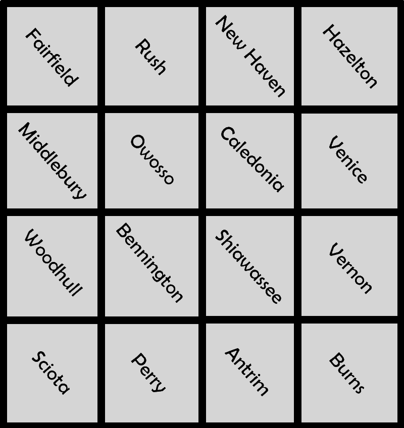
4 January 1854 - Present
Hathaway, William H. "County Organization in Michigan." Michigan History, II (1918), 573-629.
Wiskemann, Geneva Kebler, "Laws Pertaining to the Organization of Counties in Michigan." Unpublished manuscript, Michigan Historical Commission Archives, n.d.
"Reports of Counties, Towns, and Districts." Pioneer Collections. Report of the Pioneer Society of the State of Michigan, I (1877), 94-518.
"Proclamations of Governor Harrison." Indiana Historical Society Publications, III, 114.
Michigan. Territorial Laws (1805-1837).
Michigan. Public Acts (1837-1897).
* * * * *
Readers interested in the history behind the names of the eighty-three counties in Michigan are referred to the useful and concise Michigan Department of State pamphlet, "History of Michigan Counties," 1972. It is available through most Secretary of State branch offices and in many public libraries throughout the state.
* * * * *